


GPX Photo search
وصف لـGPX Photo search
"GPX photo search" is Android app to search for photos taken in journey from the photo that is stored in the smart phone or Google photo.
Since the search in the shooting time even if you do not have organize your photos, have been recorded, is a Hassle
********************************************
I do not support writing geotag of external SD card on Android 4.4+.
I think that there is no choice but to copy the files to internal storage and process them.
********************************************
To use later, is required track log data (GPX file) were recorded leg of a journey.
This will make a move if you record GPS logger app.
(The GPS logger app, and you have Mountain trip logger)
In GPX photo search, use time of the track log and time the picture was taken (Exif) to find the photo data
※This free version shows ad at screen top. GOLD is ad-free version.
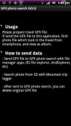
◆ How to use
Please send track log file (GPX) to GPX photo search.
[How to send]
・Place the SD card the GPX file, the file manager application (ES File Explorer, such as AndExplorer) to send
・In Mountain trip logger, press and hold the data you want to use the measurement results list screen, send in the form of share-GPX
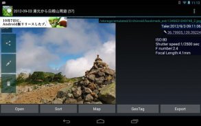
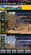
Then, the search will begin the photo. View photos from the SD card to find a smartphone, that are found.
Display mode is switched to tap the screen, you can turn off the button and find more information and get out.
If a photo does not appear that there should be a photo but if, it may be funny to set the folder that you want to search for photos.
From Menu, setting, please try to change the settings of the folder you want to search.
Models also have built-in SD cards such as the Galaxy in particular areas, you may need to be changed.
▼ function (1) View photos every time
I think the camera is handy and they accumulated a lot of photos taken in various places.
And accumulate a lot, is very well to organize manually later.
However, it is all right if and when the track log data was taken, and GPX photo search.
Search even if they are not organized a photo, you can browse every time, you can output to a file.
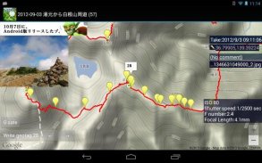
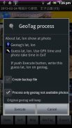
▼ function (2) Set the Geotagging Photos
As how to use slightly more advanced, the photo (geo) has not been set location information, you can also set a geotag.
(Measures of location information leakage) in the camera settings you think in many cases have taken off and then recording the geotag.
Even in such a case, fine, if the data and track logs when taken, the GPX photo search.
You can set the photo geotagging to estimate the latitude and longitude of the position taken by matching the track log time and the picture was taken, does not have a geotag.
The advantage of setting up as geotagging, apps and services that support geotagging: In (eg Picasa), you can put your photos on the map string.
Do not know when I look back later, be a more vivid memories.
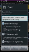
▼ function (3) Output file
It is for people who have a PC primarily, can be output to a file and search photos.
-Format ZIP (image)
Outputs a file all images taken in the journey. Can be used to take a backup on your computer, such as
-Format GPX (waypoints)
Gpx file that outputs the way point to point and shoot. You can import a point in compatible software.
-Format KMZ (track log + points + reduced image)
Outputs the data points with a track log and photos of stroke, are listed on the map. You can import in Google Earth
▼ function (4) Live wallpaper
Show photos as live wallpaper.
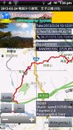
▼ function (5) Upload to Yamareco
http://www.yamareco.com/
"GPX photo search" هو تطبيق Android للبحث عن الصور التي تم التقاطها في رحلة من الصورة المخزنة في الهاتف الذكي أو صورة Google.
نظرًا لأن البحث في وقت التصوير حتى إذا لم يكن لديك تنظيم لصورك ، فقد تم تسجيله ، فهو مشكلة
********************************************
لا أؤيد كتابة علامة جغرافية لبطاقة SD الخارجية على Android 4.4+.
أعتقد أنه لا يوجد خيار سوى نسخ الملفات إلى وحدة التخزين الداخلية ومعالجتها.
********************************************
لاستخدامها في وقت لاحق ، مطلوب تم تسجيل بيانات سجل المسار (ملف GPX) ساق رحلة.
سيؤدي ذلك إلى اتخاذ إجراء إذا قمت بتسجيل تطبيق GPS المسجل.
(تطبيق GPS المسجل ، ولديك مسجل رحلة الجبل)
في بحث الصور GPX ، استخدم وقت سجل التتبع ووقت التقاط الصورة (Exif) للعثور على بيانات الصورة
※ هذه النسخة المجانية تعرض الإعلان في أعلى الشاشة. الذهب هو نسخة خالية من الإعلانات.
use كيفية الاستخدام
الرجاء إرسال ملف سجل التتبع (GPX) إلى بحث الصور GPX.
[كيف ترسل]
・ ضع بطاقة SD في ملف GPX ، تطبيق مدير الملفات (ES File Explorer ، مثل AndExplorer) لإرساله
Mountain في أداة تسجيل رحلة الجبل ، اضغط مع الاستمرار على البيانات التي تريد استخدام شاشة قائمة نتائج القياس ، وأرسلها على شكل share-GPX
ثم ، سيبدأ البحث الصورة. عرض الصور من بطاقة SD للعثور على الهاتف الذكي ، التي تم العثور عليها.
تم تبديل وضع العرض للنقر على الشاشة ، يمكنك إيقاف الزر والعثور على مزيد من المعلومات والخروج.
إذا لم تظهر صورة أنه يجب أن تكون هناك صورة ولكن إذا ، فقد يكون من المضحك تعيين المجلد الذي تريد البحث عنه.
من القائمة ، الإعداد ، يرجى محاولة تغيير إعدادات المجلد الذي تريد البحث عنه.
تحتوي النماذج أيضًا على بطاقات SD مدمجة مثل Galaxy في مناطق معينة ، قد تحتاج إلى تغيير.
▼ وظيفة (1) عرض الصور في كل مرة
أعتقد أن الكاميرا في متناول اليد وأنها جمعت الكثير من الصور التي التقطت في أماكن مختلفة.
وتتراكم كثيرًا ، من الجيد جدًا تنظيمه يدويًا لاحقًا.
ومع ذلك ، كل شيء على ما يرام إذا وعندما تم أخذ بيانات سجل المسار ، والبحث عن الصور GPX.
البحث حتى لو لم يتم تنظيم صورة ، يمكنك التصفح في كل مرة ، يمكنك الإخراج إلى ملف.
▼ وظيفة (2) قم بتعيين الصور الجغرافية
فيما يتعلق بكيفية استخدام أكثر تقدمًا قليلاً ، لم يتم تعيين الصورة (الجغرافية) على معلومات الموقع ، يمكنك أيضًا تعيين علامة جغرافية.
(قياسات تسرب معلومات الموقع) في إعدادات الكاميرا التي تعتقد أنها في العديد من الحالات قد أقلعت ثم سجلت العلامة الجغرافية.
حتى في مثل هذه الحالة ، غرامة ، إذا كانت البيانات وتتبع سجلات عندما اتخذت ، والبحث عن الصور GPX.
يمكنك تعيين علامة جغرافية للصورة لتقدير خط الطول وخط الطول للموضع الذي تم التقاطه عن طريق مطابقة وقت سجل المسار والتقاط الصورة ، وليس لديها علامة جغرافية.
ميزة الإعداد كعلامة جغرافية وتطبيقات وخدمات تدعم التصنيف الجغرافي: في (مثل بيكاسا) ، يمكنك وضع صورك على سلسلة الخريطة.
لا أعرف متى أعود للوراء لاحقًا ، كن ذكريات أكثر وضوحًا.
▼ وظيفة (3) ملف الإخراج
هو الحال بالنسبة للأشخاص الذين لديهم جهاز كمبيوتر في المقام الأول ، يمكن إخراج إلى ملف والبحث الصور.
- تنسيق ZIP (صورة)
مخرجات ملف جميع الصور التي التقطت في الرحلة. يمكن استخدامها لأخذ نسخة احتياطية على جهاز الكمبيوتر الخاص بك ، مثل
- تنسيق GPX (نقاط الطريق)
ملف Gpx الذي يخرج الطريق يشير إلى نقطة واطلاق النار. يمكنك استيراد نقطة في برنامج متوافق.
- تنسيق KMZ (سجل المسار + نقاط + صورة مخفضة)
مخرجات نقاط البيانات مع سجل المسار والصور من السكتة الدماغية ، مدرجة على الخريطة. يمكنك الاستيراد في Google Earth
▼ وظيفة (4) خلفية حية
عرض الصور كخلفية حية.
▼ وظيفة (5) تحميل إلى Yamareco
http://www.yamareco.com/
GPX Photo search - إصدار 8.3
(06-03-2023)GPX Photo search - معلومات APK
نُسخة APK: 8.3الحزمة: com.kamoland.gpxpsearchآخر إصدار من GPX Photo search
نُسخ أخرى


تطبيقات من الفئة نفسها


